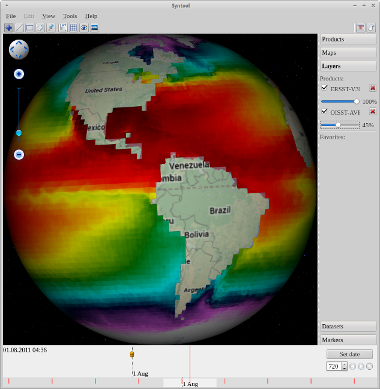
One of the lines of the laboratory – the creation of application for interactive work with the data received from satellites. So at this point being developed an interactive tool of synthesizing new generation data – SynTool Starter.
Its main advantage is the ability to make processing and analysis of satellite and other related data. SynTool Starter is a desktop application written in C + + using libraries Qt5 and is an open source platform and the 3D graphical user interface.
One of the main functions SynTool: _ display of products layers, adjustment of transparency, saving data. The layers are: charts, marine radar, maps of oil spills and ice, according to the location of ships radar with synthetic instrumentation (SAR) such as the RS2 and Cosmo SkyMed, as well as according to the Automatic Identification System, as well as a huge number of other ancillary and satellite meteorological data (sea surface temperature, cloudiness, etc.), interactive elements for access to detailed information (covering the satellite data, maps, ships, oil spills, ice, in situ measurements, etc.), access to archived data, for the visualization of past situations.
Link to git repository: https://github.com/SpiritD/syntool
Link to manual: http://wiki.solab.rshu.ru/Syntool